
GS1- Geography
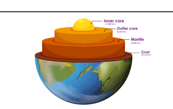
The Earth is a dynamic planet that has undergone many changes over its 4.6 billion years of history. Some of these changes are visible on the surface, such as mountains, valleys, volcanoes, and oceans. Others are hidden beneath the crust, such as the mantle, the core, and the movements of tectonic plates.
How did these features form and what forces shaped them? In this blog post, we will explore some of the major geologic theories that have attempted to answer these questions and explain the evolution of the Earth and its landforms.
Continental Drift Theory
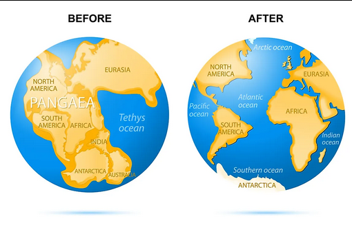
One of the earliest and most influential geologic theories was the continental drift theory, proposed by Alfred Wegener in 1912. Wegener suggested that all the continents were once part of a single supercontinent called Pangaea, which broke apart and drifted to their current positions over millions of years. He based his theory on several lines of evidence, such as the jigsaw-like fit of the continents, the similarity of rock types and fossils across the oceans, and the distribution of ancient climates and glaciations.
For example, Wegener noticed that the coastlines of South America and Africa matched each other like pieces of a puzzle. He also found that the same types of rocks and fossils were found on both continents, indicating that they were once connected. Moreover, he observed that the traces of ancient glaciers and deserts were found in regions that are now tropical or temperate, suggesting that the continents had moved to different latitudes.
However, Wegener could not explain what caused the continents to move and how they overcame the resistance of the ocean floor. His theory was met with scepticism and criticism by most geologists at the time, who preferred the idea of fixed continents and land bridges.
Convection Current Theory
In the 1930s, Arthur Holmes proposed the convection current theory, which tried to address the problem of the driving force behind continental drift. Holmes suggested that the intense heat generated by radioactive decay in the mantle created convection currents that circulated the molten rock. These currents moved the rigid plates of the crust, which carried the continents along with them. Holmes also proposed that the continents could break apart or collide due to the divergent or convergent movements of the plates.
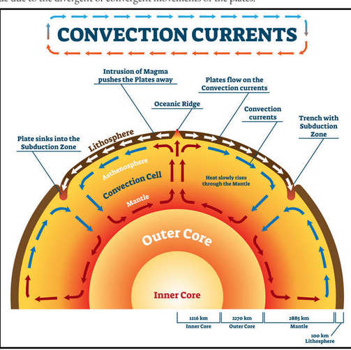
For example, Holmes explained that the Atlantic Ocean was formed by the splitting of Pangaea along a divergent boundary, where new crust was created by the rising magma. He also argued that the Himalayas were formed by the collision of India and Asia along a convergent boundary, where one plate was subducted under another.
His theory was the first to introduce the concept of plate tectonics, which would later revolutionise the field of geology. However, Holmes lacked direct evidence for his theory and could not account for the variations in the speed and direction of the plate movements.
Plate Tectonic Theory
The plate tectonic theory is the most widely accepted and comprehensive geologic theory today. It was developed in the 1960s and 1970s, based on the discoveries of seafloor spreading, paleomagnetism, and subduction. The theory states that the Earth’s lithosphere, the outermost layer of the planet, is divided into several tectonic plates that move over the asthenosphere, the ductile layer of the mantle. The plates interact with each other at different types of boundaries: divergent, where plates move apart and new crust is formed; convergent, where plates move together and one plate sinks under another; and transform, where plates slide past each other. These interactions produce various geologic phenomena, such as volcanoes, earthquakes, mountain ranges, ocean basins, and island arcs. The plate tectonic theory explains not only the current configuration of the Earth, but also its past and future evolution.
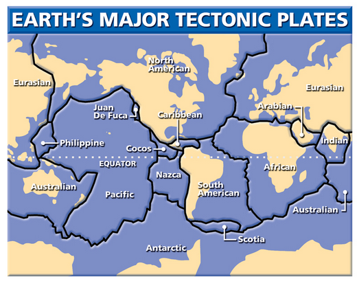
For example, the plate tectonic theory provides evidence for the continental drift theory by showing that the seafloor is spreading at divergent boundaries, such as the Mid-Atlantic Ridge. The theory also reveals that the Earth’s magnetic field has reversed many times in the past, leaving a record of the plate movements in the magnetic stripes of the ocean floor. Moreover, the theory demonstrates that the crust is recycled at convergent boundaries, where the denser oceanic plate is subducted under the lighter continental plate, creating deep-sea trenches and volcanic arcs.
The plate tectonic theory is supported by various types of data, such as the mapping of the ocean floor, the measurement of the plate motions, and the analysis of the seismic waves. The theory also helps us to understand the distribution and origin of the natural resources, the hazards and risks of the natural disasters, and the diversity and evolution of the life forms on Earth.
Other means to study interior of the Earth
Another way to study the interior of the earth is to use the measurements of gravity, magnetism and seismic activity. These methods rely on the fact that different layers of the earth have different physical properties, such as density, composition, temperature, pressure, and state of matter. By analysing the variations and anomalies of these properties, we can infer the structure and dynamics of the earth’s interior.
-
Gravity
Gravity is the force of attraction between two masses. The gravity of the earth depends on the mass and the distance of the object from the centre of the earth. The gravity of the earth is not uniform everywhere, because the earth is not a perfect sphere and its density is not constant. The gravity of the earth varies with latitude, altitude, and local geology. For example, the gravity is higher at the poles than at the equator, because the earth is flattened at the poles. The gravity is lower at high altitudes than at sea level, because the distance from the centre of the earth is greater. The gravity is also affected by the presence of mountains, valleys, oceans, and underground structures, such as magma chambers, faults, and ore deposits.
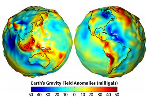
By measuring the gravity of the earth at different locations, we can map the gravity field of the earth and detect the anomalies that indicate the variations in the density and distribution of the earth’s material. For example, a positive gravity anomaly means that the gravity is higher than expected, which implies that there is a mass excess or a denser material below the surface. A negative gravity anomaly means that the gravity is lower than expected, which implies that there is a mass deficit or a less dense material below the surface. Gravity measurements can help us to identify the boundaries of the crustal plates, the thickness of the crust, the location of the mantle plumes, and the shape and size of the core.
-
Magnetism
Magnetism is the force of attraction or repulsion between two magnets or between a magnet and a magnetic material. The magnetism of the earth is generated by the electric currents in the liquid outer core, which create a magnetic field that extends into the space around the earth. The magnetic field of the earth is not constant, but changes over time and space. The magnetic field of the earth varies with latitude, longitude, and depth.
For example, the magnetic field is stronger at the poles than at the equator, because the magnetic field lines are more concentrated at the poles. The magnetic field is weaker at high altitudes than at sea level, because the distance from the source of the magnetic field is greater. The magnetic field is also influenced by the presence of magnetic materials, such as iron, nickel, and cobalt, in the crust and the mantle.
By measuring the magnetic field of the earth at different locations, we can map the magnetic field of the earth and detect the anomalies that indicate the variations in the magnetization and orientation of the earth’s material. For example, a positive magnetic anomaly means that the magnetic field is stronger than expected, which implies that there is a magnetised material or a magnetic pole below the surface. A negative magnetic anomaly means that the magnetic field is weaker than expected, which implies that there is a demagnetized material or a magnetic pole below the surface. Magnetic measurements can help us to identify the age and movement of the oceanic crust, the location and direction of the plate boundaries, the history and reversals of the earth’s magnetic field, and the structure and dynamics of the core.
-
Seismic Activity
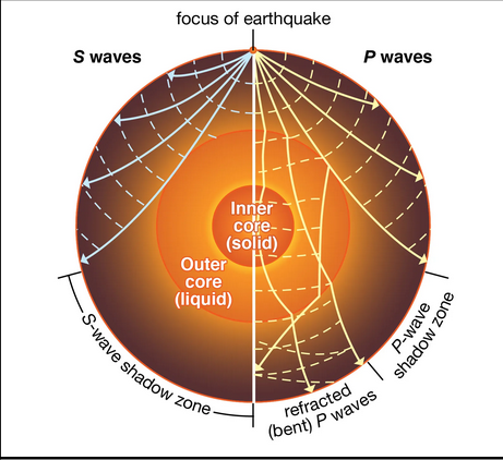
Seismic activity is the occurrence of earthquakes and volcanic eruptions, which release energy in the form of seismic waves. Seismic waves are vibrations that travel through the earth and can be detected by seismometers. Seismic waves can be classified into two types: body waves and surface waves. Body waves can travel through the interior of the earth and can be further divided into two types: P-waves and S-waves. P-waves are compressional waves that can travel through solids, liquids, and gases. S-waves are shear waves that can travel only through solids. Surface waves can travel only along the surface of the earth and can be further divided into two types: L-waves and R-waves. L-waves are longitudinal waves that cause vertical displacement of the ground. R-waves are transverse waves that cause horizontal displacement of the ground.
By measuring the seismic waves of the earth at different locations, we can map the seismic activity of the earth and detect the anomalies that indicate the variations in the elasticity and rigidity of the earth’s material. For example, a seismic wave can change its speed, direction, or amplitude when it encounters a boundary or a discontinuity between different layers or regions of the earth. A seismic wave can also be reflected, refracted, or absorbed by different layers or regions of the earth. Seismic measurements can help us to identify the depth and shape of the crust, the mantle, and the core, the location and size of the faults, the volcanoes, and the hot spots, and the physical state and composition of the earth’s material.
Conclusion
The Earth and its landforms are the result of complex and dynamic processes that have been operating for billions of years. Geologists have developed various theories to understand and explain these processes, using observations, experiments, and models. The continental drift theory, the convection current theory, and the plate tectonic theory are some of the most important and influential theories in the history of geology. They have helped us to gain a better knowledge of the Earth’s structure, composition, history, and behaviour. They have also inspired us to explore further and discover more about our fascinating planet.


